Flight vision systems
Enabling safer flight operations in low-visibility environments.
By Owen Davies
Contributing Writer
Many things are called game-changers, although most aren’t. However, when Gulfstream introduced its Honeywell-made Synthetic Vision System – Primary Flight Display to business aircraft in 2005, it was the real thing.
Corporate pilots who had seen nothing but gray or rain outside the windshield suddenly could see the terrain, obstacles, runways, approaches, their own flightpath ahead, and even traffic in 3D. The images were artificial, and looked it. Yet suddenly, neither rain nor snow nor gloom of night would keep professional pilots on the ground – or divert them into it.
This is one area in which many pros have a big advantage over their commercial brethren. Few airlines are willing to pay the cost of training pilots to use synthetic vision systems (SVS) effectively, so airliners are rarely equipped with them.
According to the Federal Aviation Administration (FAA), 91% of fatal air accidents in general aviation (GA) back in 2005 were caused by a pilot’s loss of control of the aircraft, usually during approach and landing, or by flying into terrain.
And between 2009 and 2013, the Commercial Aviation Safety Team, a voluntary organization with representatives from the major airframers and avionics companies, plus FAA and the European Union Aviation Safety Agency (EASA), studied 18 separate loss-of-control events that resulted in accidents. Some of them were fatal. The group concluded that 17 had been caused by darkness or instrument flight rules (IFR) conditions that deprived pilots of their outside visual references.
SVS provides enough help with such low-visibility environments that they have grown into a highly competitive market valued at $458.4 million in 2022. By 2028, it is expected to reach $590.2 million. Entry of unmanned air vehicles (UAVs) and air taxis into the airspace is expected to drive growth in this market for the next decade.
These days, SVS is considerably more sophisticated than Gulfstream’s pioneering display from 2005. They also come from many more manufacturers. SVS even has spread into iPhone and iPad apps.
Commonalities
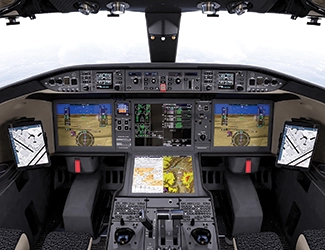
You can expect some basic features from any SVS, even those displayed on your phone. By definition, it provides a 3D picture of the terrain and obstacles drawn from a detailed geographic database assisted by GPS. The images will be remarkably realistic, especially on models with a 4K display.
Many systems highlight terrain and obstacles to point out potential hazards. SVS is integrated with flight instruments and primary flight displays (PFDs) to give flight data, such as heading, altitude, airspeed, and attitude.
Most SVS offer some form of highway-in-the-sky, displaying a series of boxes or path markers to aid in navigation and approach by guiding the pilot along a defined flightpath.
Airports and runways will be clearly marked, and could be even textured to represent asphalt, grass, and other surfaces. Detailed maps of the airport are common, guiding pilots to the appropriate taxiway.
The system will automatically adjust the level of detail shown on the display to reduce screen clutter and help pilots to focus on the most relevant information.
Now let’s look at the details of each avionics maker’s SVS products.
Aspen Avionics
Aspen markets its Evolution Synthetic Vision as an $899 upgrade to its Pro Max retrofit flight displays, intended for Part 23 aircraft with gross weights upward of 6000 lb. Basic features include 9 arc-second resolution, 3 arc-second in the continental US, which provides a crisp view of the terrain ahead on either the PFD or the multifunction display (MFD).
Altitude and airspeed are displayed on vertical scales at either side of the display. Flightpath markers show the aircraft’s GPS track and vertical speed. A built-in terrain warning system provides audio, video, and text warning messages when the system predicts a collision with local scenery or an obstacle.
With optional sensors and data, the system can display traffic and potential flight hazards in 3D.
Evolution-series flight displays with optional SVS have been approved on more than 600 aircraft models.
Collins Aerospace
Collins is an old hand at SVS and enhanced flight vision systems (EFVS) technologies. If anyone was going to mix the them into a single product, they were an obvious company to do it – and they have. Two years ago, the Collins combined vision system (CVS) received its technical standard order (TSO) for bizav aircraft.
The CVS collects infrared imaging data from Collins’s EVS-3600 multi-spectral EFVS sensor, and combines it with the company’s SVS to present the best possible image of terrain, obstacles, airports, and runways, even in hard IFR conditions. CVS images are available both on the PFD and on the Collins head-up display (HUD).
The SVS reduces landing minima from 200 ft to 150 ft, giving the EFVS a better chance to pick up the runway environment and approach lighting system. Having them both in the same display reduces the pilot’s workload during the most demanding section of the flight.
The CVS is available with the Pro Line Fusion flight deck. Collins supplies them for the BBJ 737 Max and the Bombardier Global family. It’s also available as an upgrade for older Global series aircraft and the Challenger 604; the Cessna Citation CJ1+, CJ2+, and CJ3; and the Beechcraft King Air line.

Garmin
SVS has been an optional feature of the popular G1000 glass cockpit system since 2008. Garmin has been improving it ever since. The company calls it synthetic vision technology (SVT), and it recreates the landscape from the G1000 system’s terrain-alerting database.
The display will be familiar to anyone who has used SVS. A bank indicator appears at the top, a full compass rose at the bottom, and airspeed and altitude scales at either side. Ground and water features are joined by airports, obstacles, and traffic, all shown in relative proximity to the aircraft.
A highway-in-the-sky display is available. Guidelines in each corner of the pathway show the direction of the active flight plan leg to confirm that the plane is on its intended track. Enroute legs, terminal procedures, and ILS or GPS/WAAS approaches appear in windows on the display.
In areas or at altitudes where rising terrain can be a hazard, the landscape is color-coded. Amber and red highlight towers, obstacles, and possible cumulogranite encounters.
Working with TCAS/TAS/TIS, the SVS can show relevant traffic in 3D. TCAS terminology grows larger as the potential collision approaches, making it easy to identify who might run into you.
If you have used SVS, there is a good chance it came from Garmin. Bombardier, Cessna, Cirrus, Embraer, and Piper turboprops all use Garmin flight decks. In the rotary-wing market, MD offers Garmin’s Helicopter Synthetic Vision Technology (HSVT) as an option for its civilian models. HSVT also is certified for Robinson Helicopters. And Bell supplies the G1000H NXi integrated flight deck with SVS.
Genesys Aerosystems
This successor to Chelton Flight Systems and S-TEC offers 3D synthetic vision as standard equipment with its IDU-450 and IDU-680 electronic flight instrument systems. It provides all the expected visuals – realistic terrain modeling, highway-in-the-sky course guides, attitude, airspeed and altitude scales, and traffic, as well as towers, antennas, and obstructions – all in 3D. It also provides hover vectors for helicopters, and highlights obstacles and terrain that the pilot may wish to avoid.
In all, the Genesys avionics suite has been approved on more than 700 fixed-wing and helicopter models. At this point, the company is putting much of its effort into military and special-mission aircraft. For example, it is developing an add-on supplemental type certificate (STC) to add a full Genesys avionics suite to the Sikorsky UH-60L “Lima” Black Hawk. It also is working with Airbus to enable IFR operations for the single-engine H125.

Honeywell
The SmartView SVS combines flight information from GPS, inertial reference systems, and multiple on-board databases, including the company’s Enhanced Grounds Proximity Warning System (EGPWS) database. The database has been used in more than 600 million flight hours and is credited with 30 saves from potential controlled flight into terrain (CFIT) accidents. It is updated continuously.
The display delivers the expected high-resolution 3D rendering of the topography ahead, color coded for the absolute altitude of terrain features, highlighting obstacles. SmartView also provides the standard compass, attitude indicator, airspeed, and altitude scales. Integration with Honeywell’s Interactive Navigation provides information about traffic, airports, navigation aids, and weather.
On the ground, the graphics are equally detailed. Airport renderings include runway center lines, numbering, and markers for the distance remaining, presenting a realistic environment for landing and ground ops.
SmartView images are available on the PFD or on an optional HUD.
Gulfstream’s PlaneView cockpit and Dassault Falcon’s EASy flight deck both are versions of Honeywell’s Primus integrated avionics packages. So is the Pilatus PC-24’s Advanced Cockpit Environment suite.

Universal Avionics
Universal offers the ClearVision system, a combination of SVS and EFVS. Its EVS-500 multi-spectral camera merges data from 6 sensors covering the spectrum from visible light to long-wave IFR, plus high-definition cameras to produce the best imagery possible. The combined image is available on the PFD. The optional SkyLens head-wearable display projects the combined imagery onto the pilot’s field of view for head-up flying.
ClearVision has been certified on the Boeing 737NG, the King Air B200/300, and a variety of business aircraft. It is available with a flight deck retrofit for the Dassault Falcon 2000/EX, Falcon 900B, Falcon 50, and Falcon 20; the Hawker 800; and the Cessna Citation VII.
Universal seems especially proud of its firefighting retrofit for the King Air B200. The EVS-4000 camera used by its EFVS section cuts through smoke plumes in near-zero visibility to show the core fire and the surrounding terrain, obstacles, and other aircraft. The result is close to natural vision in grayscale.
iPhone/iPad apps
ForeFlight Mobile was one of the first electronic flight bags (EFBs) to reach the market. Its top-tier Pro Plus option adds synthetic vision to the app’s basic features. The display provides a terrain profile view that highlights potential hazards, dynamic winds and temperatures. In addition, previews of weather in 3D show Internet-based icing and turbulence forecasts at various altitudes.
Garmin Pilot’s Premium upgrade adds synthetic vision with terrain and obstacle alerts to a comprehensive EFB. The program can connect with Garmin avionics to provide traffic, weather, GPS position, and attitude information on the display.
Appareo’s Stratus Insight provides a relatively sophisticated SVS. It links to Avidyne IFD series navigators to display ADS-B traffic, weather, and AHRS data on screen. A relevant traffic feature lets the pilot set a maximum distance and altitude, removing traffic farther out to unclutter the SVS image.
Uniquely, Stratus Insight also includes a speech recognition system. It transcribes clearances, ATIS, and other ATC communications into text, and records the audio messages for playback later. The software is customized for aviation, so spoken numbers appear as expected. For example, “November two two eight four Quebec” becomes “N2284Q.”
Xavion’s synthetic vision display shows not only the terrain, but highway-in-the-sky hoops and the equivalent of a complete 6-pack panel with GPS airspeed, altitude, vertical airspeed, a magnetic heading indicator, and a slip indicator. If GPS fails, it can give an approximate backup based on the iPad’s internal sensors.
 Owen Davies is a veteran freelance writer specializing in technology. He has been a futurist at Forecasting International and TechCast Global.