Reading the clouds
Pilots must be able to infer current and developing atmospheric conditions based on different cloud types.
By Karsten Shein
Comm-Inst. Climate Scientist

Looking forward at FL180, the pilot-in-command (PIC) could see what he liked to call “mushrooms” sprouting from the broken cumulus deck below him, thinking he’d be through those clouds long before they became trouble.
But both pilots began to worry as some cloud towers grew rapidly well past their altitude and the sky above them had developed a solid – but still translucent – deck. They were seeing fewer and fewer gaps of clear sky ahead.
Even though the radar was not displaying any strong returns, the pilots knew that developing storms often did not show up on radar until they matured. A brief S-turn showed that the path behind the clouds remained relatively clear.
Exercising caution, the PIC made the turn and requested a weather deviation back to the edge of the cloud deck. By the time they reached it, the ground-based radar imagery from their satellite weather link was glowing with strong cells blocking their earlier route.
Long before weather satellites or computer forecast models, people relied on the clouds to give them clues about the weather. Early pilots used their knowledge of cloud patterns to see them safely through the sky. Although we now have advanced tools that put reliable weather information at our fingertips – information that can lull a pilot into a sense of security – knowing the meaning in the clouds remains an essential pilot skill.
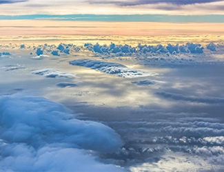
Clouds serve as good indicators of current and developing weather, because they are the visible manifestations of atmospheric dynamics. While they are simply condensed water suspended in the air, their altitude, shape, coverage, rate of growth, and movement all depend on the behavior of heat and moisture in the atmosphere. Clouds form when the air nears saturation and aerosols are present that prevent the air from easily re-evaporating the water that is condensed. This is also why you often find clouds in an unsaturated environment.
While there are dozens of different types of cloud, meteorologists separate most of them into broad categories. Based on their altitude, clouds may be cirro (high), alto (middle), or strato (low). And, based on development, they may be stratus (horizontal) or cumulo (vertical). Each cloud can tell a story about the atmosphere and help to keep pilots clear of adverse conditions.
Stratus clouds
Stratus comes from the Greek word for “layer,” and describes clouds that tend to cover the sky completely over large areas. They often form as stable air is forced to rise and cool, such as behind and above an advancing warm front. They can also form as the air at a given altitude cools or is moisturized. At lower altitudes, stratus can become quite thick. As fog dissipates from the ground up, it becomes stratus until it evaporates fully in the warming air.
At middle and high altitudes, stratus are moisture limited, so they’re usually translucent. Altostratus will normally be thin enough to show a “watery” sun, while the higher cirrostratus are almost transparent ice clouds that give the sky a pale appearance and often produce halos or other optical phenomena around the sun or moon.
All types of stratus indicate moisture in the atmosphere and, generally, the approach of stratiform precipitation. Cirrostratus are frequently present between 12 and 24 hours ahead of steady rain or snow from low- or mid-altitude nimbostratus – or precipitation-producing stratus. Quite often, stratus form around the freezing level and contain supercooled droplets, meaning that prolonged flight in stratus clouds at those altitudes should be avoided due to icing potential.
Cumulus clouds
When humid air becomes unstable, either through heating from the surface or by lifting it to where it is warmer than its surroundings, it can produce cumulus clouds that grow vertically instead of horizontally. Because they are produced by vertical air movement, pilots should expect at least light turbulence when flying near or beneath a cumulus deck.
At altitudes above 20,000 ft, areas of small, round “cloudlets” create cirrocumulus decks from turbulent airflow aloft, sometimes as part of the outflow from tropical storms, dissipation of a thunderstorm anvil, or an approaching front.
Almost always, they transform into cirrostratus or cirrus, and are frequently seen with those cloud types. They usually signify fair weather, but suggest the approach of storms, or at least precipitation, within 12 hours. When they appear in rows, it is a sign of waves moving through the upper air – and the presence of turbulence.
Similar to cirrocumulus, altocumulus occur over large areas, but with more heat and moisture in the middle atmosphere, between 6500 and 20,000 ft. An altocumulus deck can be more widely scattered than cirrocumulus, but, if there is ample moisture, they can create a solid deck or cloud streets, often covering thousands of square miles.
Pilots should become wary when the clouds start to appear tufted, suggesting increased instability and accompanying turbulence. This is also a precursor to altocumulus growing above the deck as towering altocumulus, which indicates a lot of moisture in the middle atmosphere and the potential for embedded cumulonimbus rising from lower decks.
Nearest to the surface, we often find scattered decks of puffy cumulus clouds. Usually, these clouds remain benign due to limited surface moisture or an unfavorable environment that inhibits free convection at higher altitudes. These cumulus humilis are often termed “fair weather cumulus” and signify little more than weak thermal turbulence beneath their bases.
However, as with altocumulus, cumulus decks can become solid stratocumulus, suggesting significant humidity and the potential for showers and increased convective activity in the near future. Pilots might also spot cumulus congestus, or towering cumulus emerging from the cloud deck. These clouds indicate a strong likelihood for further development into cumulonimbus. Areas containing towering cumulus or cumulonimbus should be avoided, as they will be areas that also contain moderate or stronger turbulence and potentially strong vertical windshear. Many accidents have occurred when pilots strayed into a maturing convection cell embedded in a thickening deck of cumulus congestus.

Other types of clouds
Finally, there are a few cloud types that don’t really fit into any of these categories but still reveal a lot about the atmosphere. Many of these clouds, for example, are accompanied by severe to extreme turbulence. Cirrus are cirrostratus or cirrocumulus that have been pulled into wispy filaments by strong winds and windshear aloft. They often occur downwind of thunderstorms as well as around bends in the jet stream.
Lens-shaped clouds (altocumulus lenticularis) form above and downwind of mountains, and indicate the presence of mountain waves that can produce severe turbulence.
Ragged roll and rotor clouds closer to the surface suggest extreme turbulence beneath the waves. Pouch-like mammatus, wavy asperitas, and shelf and wall clouds all accompany strong thunderstorms, and will indicate very hazardous conditions.
Even the ragged ‘scud’ we often find beneath a cumulus overcast suggests that it has been sheared from the overlying deck, and that aircraft can expect to encounter those same shear forces.
While weather-integrated avionics, airborne radar, and even widely available EFB software have made it simple for a pilot to paint a picture of what lies ahead of them, when not in IMC, visual cues in the clouds can often be the earliest and best tool for steering clear of potentially hazardous weather conditions.
If you see conditions other pilots should know about, please file a Pirep.
 Karsten Shein is cofounder of 2DegreesC.org. He was director of the Midwestern Regional Climate Center at the University of Illinois, and a NOAA and NASA climatologist. Shein holds a comm-inst pilot license.